-
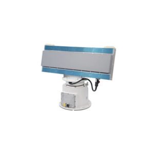
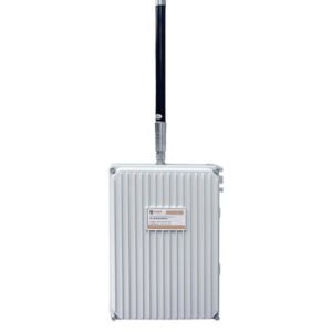
Operating system: X-band phased array system (azimuth sweep + pitch sweep)
Detection power:≥5.0km (UAV) ≥8.0km (Pedestrian) ≥10.0km (Vehicle) ≥15.0km (Boat)
Detection speed:≤0.3°(search) ≤0.3°(track)
Azimuth accuracy: ≤1.0°(search) ≤0.5°(track)
Pitch accuracy:≤5s/circle
Data rate: RJ45/1 channel 100M Ethernet
Power supply: RJ45/1 channel 100Mbps AC 220V(input) ≥250W(power consumption)
-
Detection band: 1000~1500MHz
2400~2485MHz
5150~5950MHz
Operating radius: 1km=0.6mile (external antenna up to 3km=1.8mile)
Overall Dimension: 115×56×34mm
Operating weight: 280g
Waterproof rating: IP55
Battery capacity: 29.6Wh (7.4V)
Battery life: ≥ 6 hours
-
Working Mode Radio Detection
Objects DJI series, DaoTong, Habersham, WIFI, traversing machine and other drone models
Working frequency band 2400~2500MHz / 5150~5975MHz
Detection radius distance Omni-directional antenna 700~1200m Direction-finding antenna 200~3000m (depending on the model/environment)
Direction Measuring Expansion Direction Measuring Antenna is optional
Alarm mode: light, sound
Equipment Material Alloy material
-
Support to get drone GPS coordinates, flyer GPS coordinates, return point GPS coordinates, drone model and unique serial number (regular manufacturer drone);
Detection distance is not less than the UAV mapping distance: Maximum detection distance: 18km(11miles);
Positioning accuracy: 1m(3ft)
Response delay time: 1 second;
Frequency range: 70M-6G real-time spectrum, support real-time IQ data acquisition;
Gigabit network port transmission, 5V power supply, power consumption 2W.
System continuous working time: ≥6h.
-
Detection band: 2400~2500MHz/5150~5975MHz
Detection distance:
3km=2miles(2dBi antenna/ DJI Wizard 4Pro V2.0/50m=164ft high)
6km=4miles(8dBi antenna/ DJI Wizard 4Pro V2.0/100m=328ft high)
(constant frequency without direction finding)
-
Operating frequency band 2.4GHz, 5.8GHz
Detection radius: 3Km (city)\ 5KM (open)
-
Working Frequency Band: 30MHz~6000MHz Detection Distance The farthest detection and positioning horizontal distance of DJI Elf 4 reaches 15.0KM(10miles) in the open area with no obstruction on the flat ground, and the farthest distance is 15.0KM(10miles) when taking off vertically to a height of 100M (328ft)relative to the ground.
-
Operating system: phased array system (azimuth sweep)
Frequency band: C-band X-band S-band
Detection power: 100m~1.5km(UAV) 100m~2.0km(UAV) 150m~5.0km(UAV)
Azimuth Coverage:0°-360°
Elevation Coverage:0°-30° 0°-40° 0°-40°
Detection speed:0.5m/s~30m/s 0.5m/s~30m/s 0.5m/s~45m/s
Azimuth Accuracy ≤1.0°
-

Operating system: phased array system (azimuth sweep)
Frequency band: C-band
Detection Power: 100m~1.8km (Pedestrian) 100m~3.0km (Vehicle)
Azimuth Coverage: 90
Elevation Coverage:18
Detection Speed:0.5m/s~30m/s
Azimuth Accuracy :≤1.0°
-

Operating System: C-band Phased Array System (Azimuthal Sweep)
Detection power: 30m~1.2km (vessel) 100m~3.0km (vessel) 100m~5.0km (vessel)
Azimuth Coverage:≥90° 90°/180°/270°/360° 90°/180°/270°/360°
Elevation Coverage:≥18°
Detection speed:0.5m/s~30m/s 0.5m/s~30m/s 0.5m/s~35m/s
Azimuth precision:≤1.0°
-

Operating frequency band: 2.4GHz / 5.8GHz
Decoding type: FM, WiFi, OFDM
Working radius: 2km(1.24mile)
Working angle: 360°(horizontal) ±60°(pitch)
Alarm mode: remote / cloud platform
Communication: RS422/RS485 or LAN
Power supply: POE DC15~60V 4W (max)