Showing 17–28 of 28 results
-

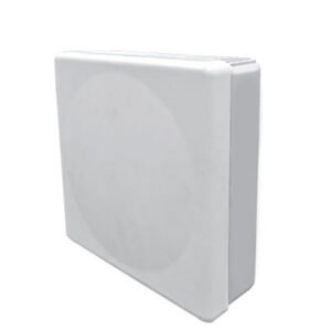
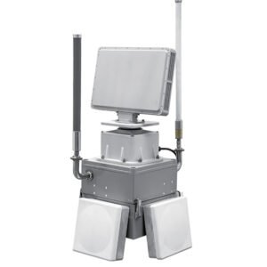
Operating system: phased array system (azimuth sweep)
Frequency band: C-band
Detection Power: 100m~1.8km (Pedestrian) 100m~3.0km (Vehicle)
Azimuth Coverage: 90
Elevation Coverage:18
Detection Speed:0.5m/s~30m/s
Azimuth Accuracy :≤1.0°
-

Operating System: C-band Phased Array System (Azimuthal Sweep)
Detection power: 30m~1.2km (vessel) 100m~3.0km (vessel) 100m~5.0km (vessel)
Azimuth Coverage:≥90° 90°/180°/270°/360° 90°/180°/270°/360°
Elevation Coverage:≥18°
Detection speed:0.5m/s~30m/s 0.5m/s~30m/s 0.5m/s~35m/s
Azimuth precision:≤1.0°
-

Operating frequency band: 2.4GHz / 5.8GHz
Decoding type: FM, WiFi, OFDM
Working radius: 2km(1.24mile)
Working angle: 360°(horizontal) ±60°(pitch)
Alarm mode: remote / cloud platform
Communication: RS422/RS485 or LAN
Power supply: POE DC15~60V 4W (max)
-

UADS-KGF33 system is developed based on the central control + message level protocol parsing technology, equipped with a UAV
The UADS-GF33 system is based on the central control + message level protocol parsing technology.
It can accurately display the serial number, model, position, speed, altitude, trajectory, remote control position and other information of the target UAV, and identify the target UAV.
It can also accurately display the serial number, model, location, speed, altitude, trajectory and remote control position of the target UAV.
After identifying the intruding UAV, it can automatically link up the jamming device and send out jamming signals to carry out countermeasures against the UAV and prevent it from intruding.
-
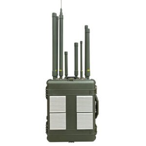
Interference frequency band 1.5G, 2.4G, 5.8G, weight 4.5kg, interference distance according to the number of matrices and the angle of the decision, the smaller the interference angle, the farther the interference distance.
-
Interference mode: omnidirectional, all-frequency interference mode
Interference frequency band: 20MHz-6000MHz, key protection band 5.8G\2.4G\1.5G\0.9G, etc.
Interference distance: 3KM(1.86) in open area, ≤1KM(0.62) in urban environment.
-
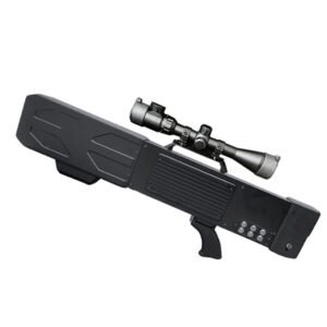
Working Mode:Radio Interference
Working band:800MHz、900MHz、1.2GHz、1.5GHz、2.4GHz、5.8GHz
Interference distance:≥2000m open field (depending on model/environmental conditions)
Antenna Type:High gain 9dB directional antenna
Antenna angle:60 degrees
Operating time:Built-in battery (24V7.5Ah), operating time up to 60 minutes
Expansion Function:Equipped with a standard rail, can be installed with scopes, night vision, law enforcement recorders, etc.
-

Control system;
Sensing system;
Integrated control platforms;
Communication systems;
Computing platforms;
Various software development.
-
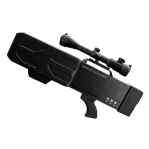
Working Mode:Radio Interference
Working band:1.5GHz、2.4GHz、5.8GHz
Interference distance:≥1500m open field (depending on model/environmental conditions)
Antenna Type:High gain 9dB directional antenna
Antenna angle:60 degrees
Operating time:Built-in battery (12V10Ah), operating time up to 35-40 minutes
Expansion Function:Equipped with a standard rail, can be installed with scopes, night vision, law enforcement recorders, etc.
-
UADS-KZC03 three-dimensional defence system integrated product design, highly integrated, scientific
It integrates four types of anti-drone systems: radio spectrum detection, radar detection, navigation deception and electromagnetic interference.
system, which can effectively control all low-altitude multi-rotor UAVs on the market, and protect the low-altitude airspace of the defence zone.
It can effectively control all low-altitude multi-rotor drones on the market and guarantee the safety of low-altitude airspace in the defence zone
-

Output frequency: GPS L1: 1575.42±1.023MHz; BDS B1: 1561.098±2.046MHz.
Receiving frequency:GPS L1:1575.42±1.023MHz; BDS B1:1561.098±2.046MHz; BDS B3:1268.52±10.23MHz.
Output power:-125dBm~-90dBm
Synchronisation Accuracy: Synchronisation accuracy of output signal ≤100ns in sync-hold mode
Abnormal alarm time: judgement, identify signal abnormality and alarm time ≤ 15s
Alarm lifting time: the time for signal abnormality alarm lifting ≤180s
<10s in reject and maintain mode
-
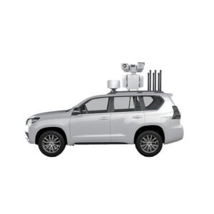
UADS-KZGL01 vehicle-mounted detection and fighting system with four phased-array monitoring radar, full-band spectrum detection, optoelectronic tracking system and full-band drone jamming equipment.
band spectrum detection, photoelectric tracking system and full-band UAV jamming equipment.
The system is composed of four parts. The vehicle-mounted design of the system is able to simultaneously realise UAV detection and tracking and jamming countermeasures functions.
tracking and jamming countermeasures at the same time. It allows the UAV to hover, land or return to its original location, thus effectively preventing the UAV from entering the area.
It allows the drone to hover in place, land or return, thus effectively preventing the drone from entering the defence zone and safeguarding the safety of low-altitude airspace.